Information about river levels
Sources of information
There are a few ways of ascertaining the level of the River Tay, however the SEPA website is probably the most reliable.
SEPA have several monitoring stations on the Tay, the nearest one to the Stanley to Thistlebrig section of the Tay is the monitoring station at Ballathie, which is 3-4km`s upstream.
Over the years there has been a succession of gauges at Burnmouth, but their calibration is unknown, and each successive gauge is calibrated differently. This website does not use them.
Changes in river levels
One of the things that became apparent when I started to collect data for this website was the abilty of the River Tay to radically change its height in a few hours. The fastest rise I have noted so far is 2 metres in around 8 hours; I don`t have a chart for that one, but here is a chart showing a rise of 1.8 metres in 10 hours that was shown on the SEPA website on 01 March 2007, and thank you to SEPA for their agreement that it can be reproduced here.
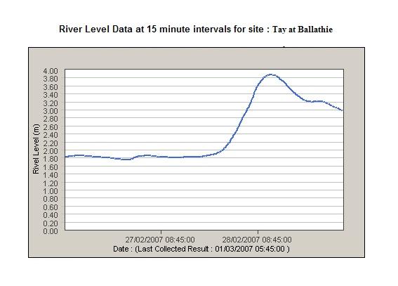
The full rise on this occasion was 2 metres over a period of 14 hours. It started rising slowly, and then accelerated.
The most recent big rise that I have seen was on 28 October 2007, when the level rose by 1.8 metres in only 6 hours - it started at 0.6 metres in height, which is a low summer level, and rose very fast up to 2.4 metres, at which level this section of the river Tay is becoming quite a serious undertaking.
I was curious as to why the Tay would have such a fast rise, so after doing some digging, here is separate web page about it
Safety warning
Don`t underestimate the skill level required to safely run this section of the river at higher levels. Although my descriptions may suggest that parts of the river are quite benign, and presenting few problems, at higher levels any mistakes can be very costly. At these higher levels, if someone takes a swim up at the weir, they will still be swimming by the time they get to, and through, Hell Hole corner - there is little chance of landing a swimmer. The river is moving very fast, and there are few eddies.
At high levels, if someone gets a bad line down the weir, they may die - some parts of the stoppers below the weir will not let go of swimmers, and rescues from a boat would be impossible.
At higher levels, I guess the skills required include the ability to read and react quickly and effectively to the water, the ability to negotiate big volume, very fast moving, grade 3+ water, and a bombproof roll.
My personal opinion is that once there is more than a few inches of water coming over the weir, this section of the river should not be run by people without these skills. Maybe about 2 metres at Ballathie, as shown on the SEPA website, would be a good threshold height.
Yes, there may be some chicken runs available depending on the level, but some of them are not that easy to get to without these skills.
website design by ron-t
website hosting by netnerd.com
© 2025 Ron Turner
![]()
![]()