A fast rise of the River Tay
Introduction
On 28 October 2007, the Tay at Ballathie rose by 1.8 metres in just 6 hours, from a very low level up to 2.4 metres.
I was curious to find out why such a fast rise occurred, and did some digging on the SEPA website, in the charts that show the levels of the various rivers that SEPA monitor, and it is quite interesting to see how it happened - perhaps !
Very many thanks to SEPA for their permission to show all the following charts that were originally shown on their website on 30 October 2007, and also for supplying some additional information about their monitoring stations.
The mathematical bit
As a way of quantifying the contribution of each tributary of the Tay to the fast rise at Ballathie, I multiplied the width of the river at each monitoring station by the height of the rise recorded by each monitoring station - this created a width-rise product for each monitoring station, and these could be compared with the width-rise product for the Tay at Ballathie.
It is only an approximate way of doing this type of quantification, but I don`t think I have enough information to do full scale cumecs calculations.
Here is how it happened - I think !
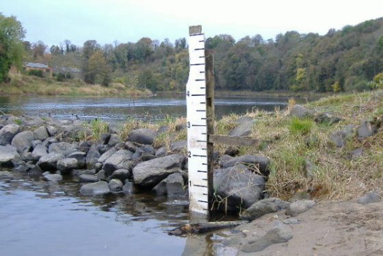
On the afternoon of Saturday 27 October 2007, I went for a play at the weir at Stanley - the river was at an amazingly low level for late October, 0.53 metres at Ballathie, which is 0.1 foot on the gauge at Burnmouth. It had been a very dry October, and the river was at an exceptionally low level for October - just for the record, here is a picture of the gauge at Burnmouth taken that afternoon.
NB - this was the old gauge, which no longer exists, it was replaced by a new one in a different place, and the calibration between the two was different.
However even as I was there, it had started to rain on the west coast, and this belt of heavy rain proceeded to cross Scotland from west to east, during the afternoon and night.
Now Loch Tay is a big loch, and although it has quite a big catchment area, the level of the loch will not change a lot as a result of a narrow belt of rain, so there would have been little change in the level of the Tay at Kenmore.
The Lyon
However Glen Lyon is a long glen with high mountains on both sides, and the only dams are right up at the west end, so the resultant run-off fuelled a large and sharp rise in the Lyon :-
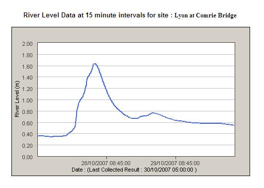
There are 14 Munros and 5 Corbetts that contribute to the water in the Lyon !
The rise in the Lyon was 1.2 metres, and it peaked at 04:15. The width-rise product was 50 m².
The monitoring station on the Lyon is right at the east end of Glen Lyon, just 2 km`s from where the Lyon flows into the Tay, just down from Kenmore.
The Tay at Pitnacree
This big pulse of water from the Lyon fed into the Tay just below Kenmore, and proceeded downstream over the next three hours, along with the water from various small rivers feeding into the Tay. You can see the effect on the Tay via the SEPA monitoring station at Pitnacree, just along the road from Grandtully.
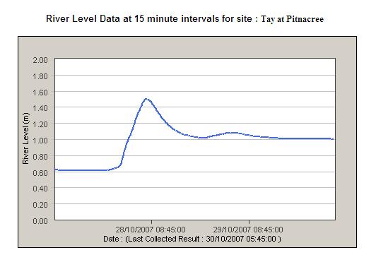
The Tay at Pitnacree rose by 0.9 metres, and it peaked at 07:15. The width-rise product was 63 m², so most of the rise in the level of the Tay at Pitnacree came from the Lyon.
The difference in time between the peaks at Comrie Bridge and at Pitnacree is 3 hours, there is 17 km`s between them, so the average speed of the peak down that section of the Tay was 5.7 km/hr.
The Tilt
Meanwhile the rain was also falling in Glen Tilt, another narrow glen with high, steep sided, mountains on each side, fuelling a sharp rise in the River Tilt :-
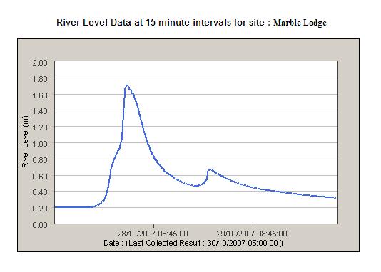
The Tilt rose by 1.5 metres, and it peaked at 01:45, which is much earlier than the other rivers talked about on this web page. This is probably because the monitoring station on the Tilt at Marble Lodge is up the glen a bit, right at the foot of some of the mountains that contribute water into the Tilt. In fact the position of the monitoring station means that not all the burns that flow in to the Tilt are actually monitored, as they join the Tilt below Marble Lodge.
The width-rise product was 37 m².
The Tilt flows into the river Garry at Blair Atholl.
The Bruar Water also flows into the Garry, a bit above Blair Atholl. So it would supply some water into the Garry, but although it is a long river, it flows through fairly open moorland over quite a lot of its length, so there wouldn`t be a fast response to a short belt of rain, especially if there had been a prolonged dry period before the rain arrived.
The Garry and the Bruar Water are part of a large complex network of tunnels, dams, power stations, and lochs - including Loch Ericht, Loch Garry, Loch Errochty, Loch Tummel, and Loch Rannoch - the whole system has for many years provided a substantial amount of renewable energy for Scotland.
The Tummel
The Garry flows into Loch Faskally alongside the Tummel, another river that contributes to renewable energy generation. Loch Faskally is a long narrow dam controlled loch. The SEPA monitoring station on the Tummel at Pitlochry, below the dam on Loch Faskally, does show a big rise in level. However the source of it is unclear - it could have been overflow, or it could have been an intentional release.
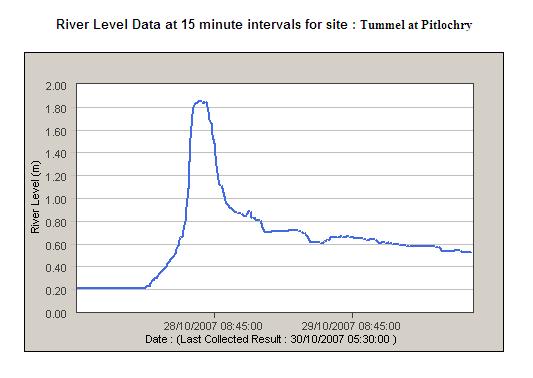
The Tummel rose by over 1.6 metres, and it peaked around 06:15, and it is quite a big river at 70 metres wide, so that means there was a big increase in volume of water - the width-rise product was 100 m²
Judging by the shape of the curve, it looks like a dam release. I reckon that this rise in the Tummel contributed more than half of the rise in the Tay at Ballathie.
The Braan
Further down the Tay, the Braan also had a significant rise :-
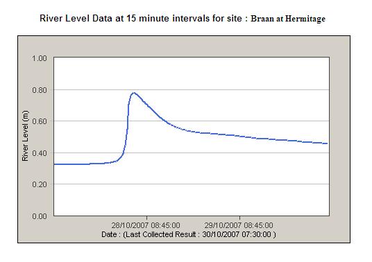
The Braan rose by just under 0.5 metres, and it peaked at 05:00. Now this is quite a bit earlier than the peaks in the levels of the Tay at Pitnacree, and in the Tummel at Pitlochry. Also, the Braan joins the Tay much further down river than Tummel, so the peak in the Braan would have arrived at Ballathie quite a bit before the peaks from the Tay at Pitnacree, and from the Tummel. In addition, the Braan isn`t really a big river, and the width-rise product was only 14 m², so I don`t think it contributed at all to the fast rise of the Tay.
It is a bit odd that there is only one peak in the Braan, because whilst you wouldn`t expect to get a peak coming down the Braan from Loch Freuchie, I would expect to get one from the Ballinloan Burn, and a second one from the Cochill Burn. Maybe the ground doesn`t allow a fast run-off, after a longish dry spell.
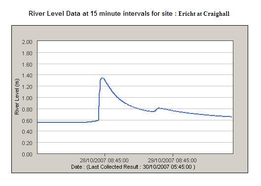
The Isla and the Ericht
The next tributary down the Tay is the Isla - and the Isla has itself an important tributary, the Ericht. We can look at these separately, because SEPA monitor their levels separately.
The Ericht has an amazingly large catchment area - from the east side of Ben Vrackie ( just above Killiecrankie and Pitlochry ) right across to the western side of Creag Leacach and Glas Maol ( the east side of the Glenshee ski area ). Most of this catchment area is fairly open hill and moor, but a small amount of it is very steep high sided mountain, which would produce a fast run off.
The monitoring station for the Ericht just below Craighall shows a very fast rise of 0.8 metres, and it peaked around 07:45. The width-rise product was 35 m².
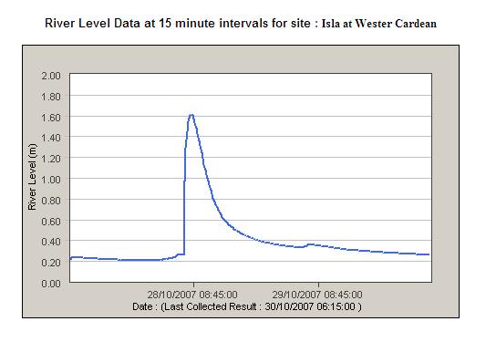
The Isla also has a large catchment area, right up to the east side of Creag Leacach and Glas Maol. A small amount of this is steep and high sided mountain, some of it is more open hill and moor, and a lot of it is low level open countryside.
The monitoring station for the Isla located at Wester Cardean also shows a very fast rise, this time of 1.4 metres, and it peaked at 08:45, with a width-rise product of 34 m².
The Tay at Ballathie
Finally we get to the monitoring station on the Tay at Ballathie, and here is the chart showing the very fast rise of 1.8 metres.
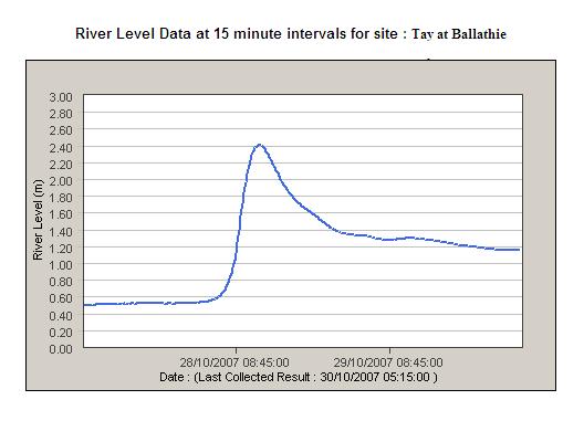
It peaked at 12:45, and the width-rise product was 162 m².
In conclusion
From all the above, it looks as if the fast rise at Ballathie was caused by a combination of the peaks on the Tummel and the Ericht, arriving at Ballathie at virtually the same time, with the Tummel providing more than half
The monitoring point on the Tummel at Pitlochry is about 39 km`s from Ballathie, the difference in time is 6.5 hours, and so the average speed of the peak down the river is 6 km/hr.
The monitoring point on the Ericht at Craighall is about 25 km`s from Ballathie, the difference in time is 5 hours, and so the average speed of the peak down the river is 5 km/hr. The Isla is quite a meandering river, so a lower speed is quite likely. The peak from the Ericht certainly didn`t arrive much before the peak from the Tummel at Pitlochry, because there is no sign of a peak or rise in the level of the Tay at Ballathie before the main rise.
The Tay at Ballathie had a width-rise product of 162 m², and the sum of the width-rise products for the Tummel and the Ericht, is 135 m². That does leave a shortfall, but I can`t see what other rivers could have contributed to the fast rise at Ballathie. There are some small rivers which flow into the Ericht and the Isla below their respective monitoring stations, but I don`t think they would produce enough water to make up the shortfall.
The peak from the Tay at Pitnacree ( ie, this is mostly the peak from the Lyon ) would have arrived about an hour later than the peak from the Tummel, so wouldn`t have contributed much to the fast rise at Ballathie, but would have contributed to the long tail after the peak at Ballathie.
The peak from the Isla would also have arrived at Ballathie about an hour after the peak from the Ericht, so again, this would contribute more to the tail, rather than the fast rise.
The peak from the Tilt, and possible peaks from the Garry and Bruar Water, would have been absorbed by Loch Faskally.
I also have another puzzle - the chart for the Tay at Ballathie doesn`t show any kind of a small peak before the main rise. I would have expected to see some form of a peak corresponding to the peak from the Braan, but there is no sign of it. Maybe it just wasn`t big enough to produce a noticeable effect on the Tay.
After all that
I am not sure if I have achieved what I set out to do - I haven`t really got a definitive answer as to what caused such a fast rise in the Tay at Ballathie - but it has been very interesting doing all the digging to find about it, I have learned a lot about the geography of the whole area, plus a bit about hydro developments and river level monitoring.
website design by ron-t
website hosting by freevirtualservers.com
© 2024 Ron Turner
![]()
![]()