Features and photos
This section of the Tay has been too good a resource for mankind not to have been spent the last few hundred years modifying it. A plentiful supply of water, a significant drop in height, and good runs of salmon have meant that over the years the river has seen the development of artificial islands, three weirs, two lades for mills further down river, a tunnel, numerous groins, a huge mill, and now a hydro power station. Some of these developments provide useful play spots, in addition to the various natural ones.
Some of these developments have little impact on boaters, two of the weirs only cover part of the width of the river, and you barely notice them, and the tunnel doesn`t really impact at all.
This page describes and shows some of the various features that make this section of the River Tay such an attractive venue for canoeing and kayaking.
The Linn
The Linn marks the end of the long flat section of the river, coming down from the SCA access point at Bridge of Isla, and is characterised by 3 islands in the river - two of them are high lumps of rock, and the third one is a much longer one, covered in trees, and with another high lump of rock at the top end.
At the Linn, at low levels, all the islands become one, and the river squeezes through a narrow gap between rocks, producing a fast chute of water on the river left side. Looking up river from further down, it looks like this :
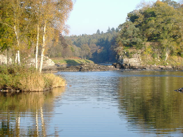
At very low levels, the chute of water is green and quite benign, and presents few problems to navigate down it.
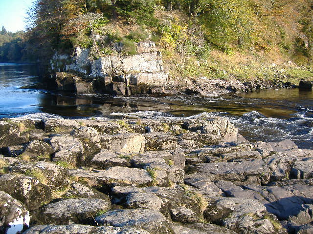
There is nothing of interest on the river left side of the chute, but the right hand side has a rocky ledge ( just left of centre in this picture )-
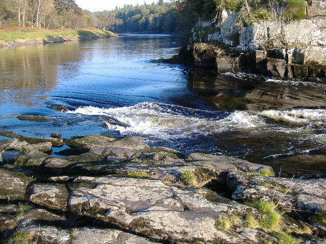
which can produce a good play spot at slightly higher levels - the pourover is good for side surfing, and the hole can be escaped from with a bit of effort. However at significantly higher levels, stay away from it - the water below the pourover is washing hard upstream straight into the now very deep hole, and I don`t think you would ever get out of it. On the other hand, if the river is still below the level at which the rocks are covered, then you can land on the rocks not too far from the hole, so the possibility exists of using it as a place to do throwline rescues.
At higher levels, the small wave just right of centre in the above photo develops into a significant wave which may or not be surfable depending very much on your boat. Skill level helps as well !
At much higher levels, the wave becomes huge - if you want an experience you will not forget, paddle down this part of the Linn when the river is around 2 metres high at Ballathie - you paddle straight down towards the wave, then turn to the left and skirt round the end of it. Just before the wave there is a big drop in the water level which you don`t see when you are standing on the rocks, and you end up looking straight into a vertical wall of water nearly 2 metres high with a top which curls towards you. It is an amazing sight.
Below the smooth green chute and the wave, the river is rather confused, and at all levels except the very lowest, you will find a series of large boils and huge whirlpools, which will happily consume any passing paddler and his boat. Unless you are into underwater boating, this stretch is best avoided.
At higher levels, the river flows over the rocky channels between the islands, and when the river is much higher, the channels start to merge. This is what it looks like at 3.6 metres.
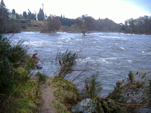
When the river is around 1.8 - 2.2 metres high at Ballathie, the various channels down through the rocks and islands provide some great grade 3-ish runs, and they are worth spending quite a bit of time at. I reckon that at these levels, the Linn is the best bit of the whole section of the river, from Stanley to Thistlebrig.
Linn bypass
What you can`t see in this photograph is a route which opens up at higher levels, to the river right of the long island. This route produces a significant river in its own right, which you could grade as 2 or 3. You do have to be good at avoiding trees, as it is rather overgrown in places. If you have come down from Bridge of Isla, if you keep close to the river right bank as you approach the Linn, you will easily get into this river, and it can provide the easiest way down the Linn. At the lower end of this river, it splits into two, and unless the Tay is very high, the first exit on the left is the best option.
1.8 metres at Ballathie is about the lowest level of the Tay for which this bypass is worth using - at lower levels, it gets very bony at the bottom end, and it dries up completely when the Tay is much lower than that.
However be aware that at much higher levels, the Linn bypass becomes a death trap - the upper part is a typical grade 2/3 river in flood - no eddies, into the trees, big waves, big volume, very fast moving - this would be okay if you have the skills to cope with it.
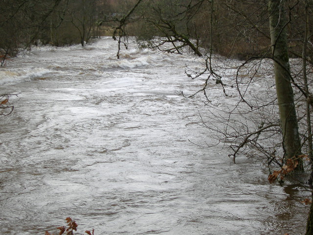
But at the lower end, there is very strong current straight into a belt of trees - it is very unlikely you would survive this. Trying to turn to get out of the exit route would mean that you would be washed into the trees broadside on.
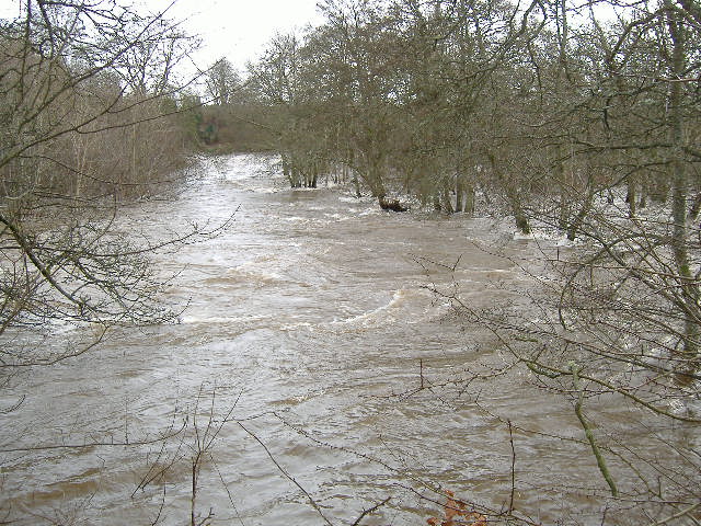
So at much higher levels, don`t try to use the Linn bypass.
Wall
The wall is a man-made stone construction at the bottom end of one of the islands below the Linn. Looking up river from further down the river, it looks like -
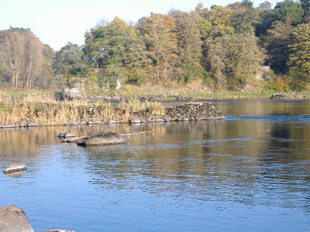
In this photograph, the river is flowing from left to right, and at this level, the eddy line is rather poorly defined. The wall is much better when the river is well up the wall, but not coming over the top of the wall, as you get a much more defined eddy line deep down below the surface, so tail or bow squirts are much easier to achieve.
You are just seeing a bit of the Linn over the top of the grass, on the left side of the photograph.
Wave right hand side of wall
Round the corner of the island to the right of the wall, there is a rather messy collection of rocks and rock shelving.
At medium levels, a wave forms just off from the middle, and it can provide a mediocre wave which is sort of surfable. It will not win any prizes, but maybe worth a look once you have tired of the wall.
Heading back down towards the get-in point
There is a bit of a rapid below the wall, and at some levels some waves can form. Some people seem able to catch them for a bit of surfing.
On your right, the two exits of the Linn bypass join the main flow.
Also, on your left as you are coming down the rapid, there is an island which is covered in trees. At the bottom of this island, between the tail of the island and the river left bank, there is a man-made line of boulders stretching out from the bank towards the island.
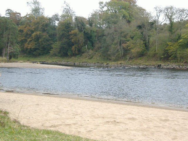
At higher levels, there is sufficient water coming down the channel river left of the island to form a significant wave at these boulders, which is worth trying to surf. The wave washes river right quite strongly, so you need to aim for the river left end to start with.
Be prepared for the fact that it isn`t possible to paddle round the tail of the island and get onto the wave - the open water you have to cross is running too fast. So if you want to try out this wave, either come down the river left of the island, or come round the tail of the island and ferry glide across to the river left bank below the wave, and find a way back up. At some levels, you can punt a kayak up over the rocks hard river left, without getting out.
Again, unless it is in really good form, this wave isn`t going to win many prizes, but at some levels, it is definitely worth a try.
Above the weir
Because of the weir, the river above the weir forms what looks like a small loch - however it does still have a current over most of its width. At high levels, this is quite a strong current, so unless you know exactly what you are doing, stay well away from the weir - at least 200 - 300 metres upstream of it.
Weir
This was I think originally built in order to feed the river into the tunnel that supplied water to the water wheels in Stanley Mill. Nowadays the same tunnel is used to drive a hydro power station located just upstream of Stanley Mill.
So the weir has quite a long history, and at the moment, it is slowly disintegrating, bit by bit. From the river left bank, when the river is at a very low level, it looks like -
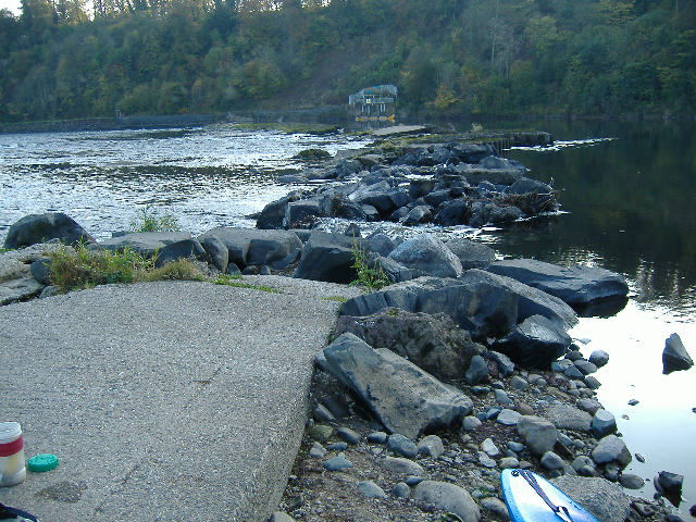
You can see how broken the weir is becoming. The two small "rivers" in the foreground were formed during the very high levels of the Tay during the winter of 2006 / 2007, when a substantial quantity of very large boulders were washed away.
Jammed up against the middle of the weir is the remnants of a huge multi-trunked tree that was washed down the river during the winter of 2006 / 2007. There is nothing surer than the fact that this tree will eventually punch another hole through the weir.
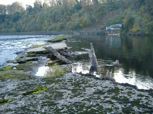
It would be nice to think that if and when the weir gets rebuilt, we can get a purpose designed wave built into the weir for playing on - it would be a great asset ! It would also mean that the area around the weir could be developed so that the area used for boating could be completely seperated from the area used for fishing.
But back to the present :-
At lower levels, there are three large chutes down the weir. Different people have differing views on which chute is the best one to paddle down, my preference is the middle one.
The river left chute, with the corrugated metal sides, is probably the easiest one, but the water coming down this chute runs diagonally across to the right to join the current from the middle chute, and in doing so there is quite a lot of very confused water to navigate through - so this lessens its attractiveness as a route down the weir.
The middle chute looks quite intimidating, but is reasonably straightforward if you just follow the main current right down the middle through the big waves, and then round to the right.
The river right chute is reasonably clean, but runs into some rather broken waves and lumpy water, so to me, it isn`t an attractive option.
At very low levels, the middle chute has one or more waves which are very definitely playable, although sadly, each year the waves seem to get less defined, and less playable. The very high levels during the winter of 2006 / 2007 have changed the wave considerably for the worse, and it is now much more dificult to play on it than it used to be.
At higher river levels, when the river starts to flow over the whole width of the weir, the river takes on a whole new character. The long sloping top of the weir means that significant stoppers form at the bottom of the weir, and when there is just a few inches of water coming over the weir, they are quite playful.
However as the river rises and more water comes over the weir, they quite quickly become much more serious holding stoppers, and at high levels, some of these stoppers are killers - there will be no escape, and rescue by boat would be impossible.
As the river rises, the middle chute continues to provide a route down - however it becomes progressively harder for two reasons -
- it becomes increasingly difficult to find it - as you approach the weir from above, there is no variation in the horizon to show where the middle chute is - if you don`t know exactly where it is, you are in trouble
- the water coming down the chute is flowing quite strongly from left to right, and at quite high levels, flows straight into a large tubular wave which can make quite a meal of you if you are not up to playing on it - a possible route is to start at the left side of the chute, and to paddle diagonally hard left until you are below the tubular wave
If the river level is above about 2.5 metres at Ballathie, then the middle chute is getting harder to find.
If the river level is above about 3 metres at Ballathie, then the left to right diagonal current immediately below the middle chute is getting quite pronounced.
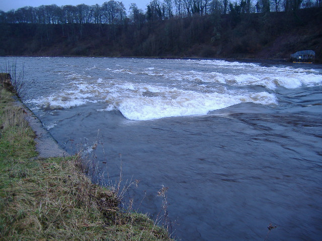
However, as the river rises, and the middle chute becomes quite a problem, once the river level is above about 3 metres at Ballathie, then a chicken shoot opens up at the very river left end of the weir - to run it, start very close to the stone wall, and head slightly diagonally right. This photograph shows it when the river level is at 3.6 metres at Ballathie.
Rapid down to Hell Hole corner
At all levels, the main flow down this section is left of centre. At most levels it is quite straightforward, although at some lower levels, the ability to move sideways left and right whilst coming down the rapid would help to avoid the bigger obstacles.
This bit of the river is most fun at lower levels, when the man-made groins coming out from the left bank are creating some good eddies, resulting in some playspots, as well as providing good sites for intermediate paddlers to practise break-ins and outs.
Also, at the lower levels, there are some good waves and pour-overs scattered throughout its length.
At quite high levels, it flattens out almost completely, and becomes virtually featureless. However it is moving very fast, so don`t be misled by this. And you are being pushed inexorably down towards Hell Hole corner.
At high levels, it is probably best to stay well left of centre, in order to avoid the confused water caused by the two man-made lines of boulders, stretching out from each bank, just a bit above Hell Hole corner. After they have been passed, head over to the right a bit.
There is nothing of interest to boaters the whole way down on the river right side of the river, at any level.
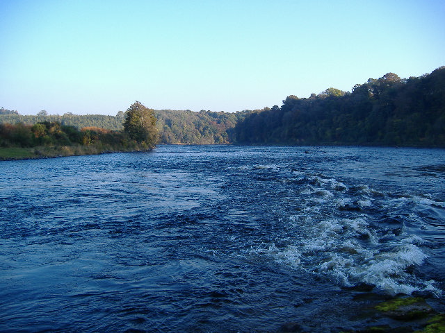
This photograph was taken from the weir, looking straight downriver, when the river was quite low.
Hell Hole corner
At Hell Hole corner, the river changes character again - and pay attention to the name. Over the years, the river has cut a slot through a large rocky ridge, and there are cliffs on either side. In just 200 metres or so, the river bends hard round to the right, and doubles back on itself. It also drops several metres at the same time.
At all levels, it provides some form of a challenge.
At low and medium levels, the main current is right of centre, and it flows over a series of rocky ledges, and then into a long wavetrain, with sometimes quite surprisingly large waves.
Also at lower and medium levels, over on the left side, there is an elevated section, with a small but quite tricky diagonal wave. This is followed by a smooth area before it drops over an edge to the rest of the river below. At some levels you can get a superb shallow green wave just above the drop.
The drop produces some excellent playspots, at one end there is a very grippy stopper, and the rest can have quite powerful stopper/waves.
At high levels, Hell Hole corner is a very confused place, with large standing waves, strong cross currents, and haystacks, all mixed up. Not for the faint hearted !
Fortunately, once the level at Ballathie is up to around 3.4 / 3.6 metres, there is a superb and very surprising chicken run very hard right, just below the cliff.
If you want to avail yourself of this chicken run, then make this decision before you run the weir. After the weir, follow the main current left of centre for a couple of hundred metres, then work hard to get yourself right over the right hand bank long before you get to Hell Hole corner. Just above Hell Hole corner, there is a man-made line of boulders stretching out across the river from the right hand bank. Below this line of boulders there is a somewhat unpleasant mixture of waves and stoppers, and you don`t want to be paddling through them. You need to be beside the right hand bank before you get to this line of boulders. Find a way over this line of boulders close to the bank, then follow the smooth water all the way round the corner.
Be warned - it isn`t easy to get over to the right hand bank when the river is that high - it takes a lot of determined effort.
If you want to inspect Hell Hole corner when the river is at this sort of high level, then just above this line of boulders is the only place that you will be able to land, and you land almost on to the track.
Hell Hole corner to Thistlebrig
There isn`t really much of note on this whole section of the river, which you could grade as grade 1 below Hell Hole corner, and grade 2 as you run down towards Thistlebrig.
Just up from Stanley Mill on the left, at quite low levels only, there is a nice hole which can provide a lot of fun, though usually only for a short time. At higher levels, it washes straight through, and as the river gets higher, it disappears all together.
Just above and below the Mill on the right, there are two groins coming out from the bank, and at some lower levels they can produce some small holes/waves which can provide a little fun. When the river level is around 1.8 metres at Ballathie, the groin just above the mill produces some quite significant stoppers, rather than waves.
Thistlebrig
At Thistlebrig, the river is squeezed down a bit in width, and at low and medium levels, it follows a distinctive "S" shaped path. The run down towards the "S" can be a bit rough, and at low levels, a couple of significant holes open up in the middle of the "S", and are worth playing in.
There are eddies on either side of the lower part of the "S", and the one on the right has a habit of catching out less experienced paddlers who have successfully negotiated the "S", then relax, and get snarled by the eddy line.
There can be quite good waves river left over from the bottom of the "S".
At high levels, the river flows over the top of the rocks on the left, and so loses the "S" shape. At these high levels, the whole left half of the river is quite rough and best avoided, and the best route down and through Thistlebrig is to run down towards Thistlebrig right of centre, and as you approach the narrows, look for a smooth dark wedge of water right of centre, and follow that down through. At these higher levels, there is usually quite a large eddy river right, which you can break out into from the wedge without too much difficulty.
Wave below Thistlebrig
Approximately 100 - 200 metres down river from Thistlebrig, on the right, there is a rocky shelf. At higher levels it can provide a superb playwave.
At all levels at which it is useable, the wave is in two distinct parts - the river left side is steep, with a foam pile that goes virtually all the way into the trough, and is a playboaters dream. The river right side is smooth and green, and superb for surfing. There is very little separation between the two halves, it changes quite quickly.
The wave is at its best when the level at Ballathie is between 2.2 metres and 3.0 metres, and at these sort of levels, this wave is by far the best bit of the whole river.
Below 2.2 metres, the wave is too short, and at levels much lower than that, it eventually disappears altogether.
Above about 3.0 metres, it is getting a bit washed out for surfing on the river right side, though it may still be useable on the river left side.
This is what it looks like when the river is 2.6 metres high at Ballathie :-
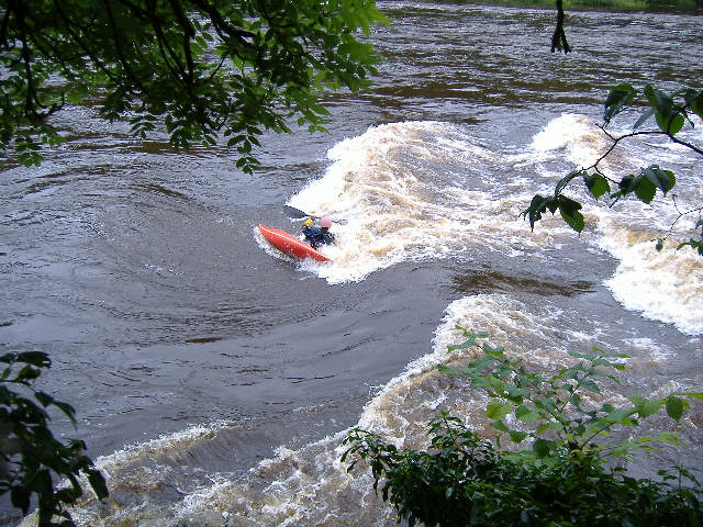
You can`t complain when there is a wave like that !