Falls of Lora home page
These pages contain information about kayaking on the Falls of Lora - in both sea kayaks and playboats - and both on the flood tide and on the ebb tide.
The Falls of Lora are a few miles north of Oban on the west coast of Scotland, where the sea loch Loch Etive connects to the sea through a narrows at Connel - the limited width of Loch Etive at Connel means that there are significant tidal currents through the narrows.
In addition to the restriction in the width of the loch at that point, immediately to the east of the restriction there is a reef of rock which occupies about half the width of the narrows. Most of the time this reef is under water, but it just appears for around an hour or two at Spring tide lows.
Much of the flow through the narrows is forced around the ends of the reef.
This reef, combined with the narrows, results in the Falls of Lora producing one of the fastest tidal currents in the UK. In addition, the existence of the reef right in the middle of the narrows results in significant white water features like waves, holes, and whirlpools, both on the ebb tide and the flood tide, although the features are very different between the ebb and flood tides.
These white water features are very dependent on the tidal height range - at Spring tide ranges of around 3.9 - 4.2 metres in height, they are very powerful, with considerable play potential for advanced kayakers. At Neap tides they don`t really exist.
In general terms, the waves produced by ebb tides are more suited to playboats, and the waves produced by the flood tides are more suited to sea kayaks, or longer river boats.
Although the Falls of Lora are usually associated with the more extreme end of kayaking - both in sea kayaks and in playboats, during the Neap tides the whole narrows becomes a more normal tidal playground - the water is fairly flat, but still has features like wide tidal streams, narrow fast chutes, eddies, boils, and whirliepools.
Connel bridge
Added to the natural restrictions to the tidal flow is a man-made feature, Connel Bridge.
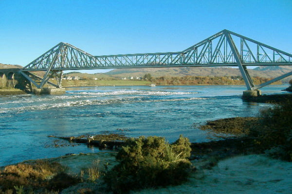
As you can see, it is a very impressive structure - it was built as a railway bridge, and opened in 1903. In 1916, a roadway was added so that motor vehicles could also cross over the narrows - but owing to the lack of width of the bridge, the roadway was closed when a train needed to use the bridge. In 1966, the railway closed, and the bridge became a road bridge.
The bridge has various claims to fame, depending on where you get the information from. Some sources say it is the second longest cantilever bridge in Britain. Some sources say it is the longest cantilever bridge in the world. And some sources say that when it was built, it was the second longest single span bridge in Europe. Which of them are true I don`t know, but it is still an impressive structure. It cost £45,000 to build - what would it be if it had to be replaced at today`s prices ?
The important thing about this bridge as far as kayakers are concerned is the two stone piers that the bridge sits on. On both sides of the narrows, the piers are a few metres out from the bank, and at various tide levels they create more features of interest to kayakers.
It is not too clear in this picture, but the north pier (on the left of the picture) is just the same as the south pier.
Tides at the Falls of Lora
Because of the restriction to the flow of water, the height of the tide within Loch Etive never catches up with the height of the tide to the west of the narrows, and the time of the tides in Loch Etive is always later than the time of the tides to the west of the narrows.
Here is a separate page about the effects this has on the tidal flow through the Falls of Lora
Spring tides
Playing at the Falls of Lora is very dependent on the tides, in particular, the Spring tides - so I have been doing a little digging to find out more about them. Looking at a set of tide tables provides information about the size and times of tides, but not about the causes of them.
I ended up with a bit too much information to put on this page, so it is on a separate page, and here is the link to it.
Spring tides at the Falls of Lora
The ebb tide
It`s the ebb tide that gives the Falls of Lora their name - and if you want to see them at their best, aim to be there round about low water at Oban, right in the middle of the Springs, and if you can, look for a Spring tide with a large high tide height, and a very low low tide height. This timing will give the biggest difference between the levels of the sea and Loch Etive, and the most impressive view of the water cascading over the rocks.
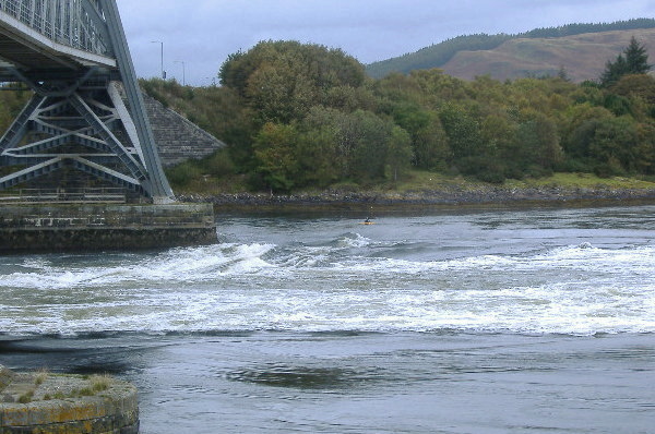
I have found it quite difficult to produce photographs of the water features, because they are so small compared to the width of the narrows - the narrows are some 150 metres wide, so a wave 2 metres high looks insignificant in comparison.
However here are two photographs which gave a general view of the white water during the ebb tide. The first one shows the general location of the main waves that are used by playboaters. This is looking north across the narrows, and the play waves are just to the right of the north pier, ie, the far away pier.
Slightly round to the right, the reef is almost appearing, with the long stretch of white water downstream of it.
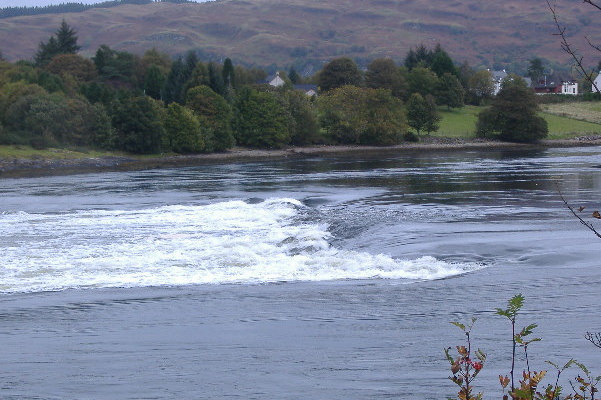
Don`t be fooled by the flat water in the foreground - it may be flat, but it is flowing at one heck of a rate under the bridge and out to sea. It is actually quite a deep channel, and is used for access to Loch Etive by quite large ships going to and from a large quarry on the north side of Loch Etive, not far from Bonawe.
I haven`t played much on the ebb tide, but if you are interested in playing on the ebb tide, here are a separate with several photographs and YouTube videos showing various playboats in action on some of the bigger Spring tides.
Quite apart from that kind of playing on the ebb tide on the falls themselves, immediately downstream of the falls and the bridge, the various fast current streams and eddies provide an excellent training ground for learning about tide race paddling, and are regularily used for this. The flood tides don`t really offer such a good facility for this as the ebb tides, and during Springs, you would probably get 3 or 4 hours of good practice time, in the middle of the day, right beside the launching place.
The flood tide
During the flood tide, the features are very different - there are two main features of interest to sea kayakers.
The first one is a wave that forms during the later part of the flood tide to the north of the north pier, between the north pier and the sloping rocks. It can be an excellent playwave for sea kayaks, I have accumulated a bit too much information to put it all here, so it is on a separate page, and here is the link to it.
the north pier in a flood tide
The second feature of interest to sea kayaks is where the incoming tidal flow meets the reef, and produces a ramp, and a series of green waves. They are nothing like the waves on the ebb tide, they are far too flat for playboats, but are suitable for sea kayaks - again they can sometimes produce excellent surfing.
Again, a bit too much information for this page, so here is a link to a separate page about them.
the middle waves in a flood tide
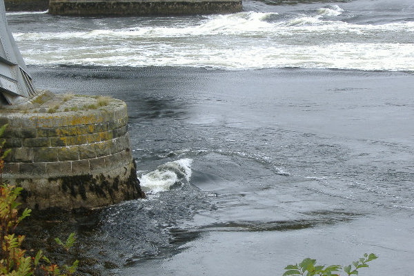
The south pier
At most tide levels, the rocks on the south side of the south pier are high and dry - here it is at a fairly low tide level -
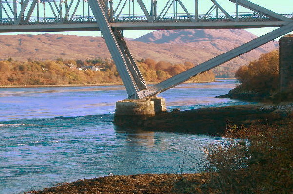
You can see from the seaweed line that it needs a high high tide to get water flow. So the south pier provides a major obstruction to the outward tidal flow - and there is a rather nice looking very short and steep green wave that should have playboat potential.
One of the things about the south pier in a flood tide is that you would expect to be able to use the channel to sneak westwards past the bridge. Or if there isn`t enough water, to climb over the rocks. Unfortunately it doesn`t work - about 100 metres or so to the east of the bridge, there is a sort of point with a fishing platform on it. You can paddle past that point as there is a bit of an eddy, but then you stop - you are looking up at a smooth ramp of very fast moving water, and there is little possibility of paddling up it. So I don`t think there is any way to get to the channel or the rocks. The ramp is caused by a slab of rock a few metres wide, and extending about 5 metres out from the bank - I guess it is part of the main reef, but separated from it by the deep channel.
If it is part of the reef, it is interesting to speculate as to whether the deep channel is actually man-made - was the reef blasted to allow ships up to the quarry - was the quarry opened in order to provide stone for the bridge ? Looks like a little industrial archaeology is called for here !
The north pier in an ebb tide
I have only been to that channel once during an ebb tide, and I wasn`t all that impressed. There was a bit of a wave, but it was continually changing shape, and out of the hour or so I was there, there were only a few minutes when it was actually surfable. Maybe I was unlucky, or my timing relative to the tides was wrong. I don`t think it was a particularily high tidal range on the day I was there. In theory, the ramp should produce a significant stopper.
When I was there, there was a very fast quite narrow chute of water below the wave, and it was an interesting place to practice crossing that kind of fast stream, as there is an eddy either side. It does wonders in developing your skills in edging and leaning a sea kayak.
However there is something to be aware of - on the south side of the stream, ie, river left, the eddy is huge - and for some of the time, this eddy flows right up the outside of the pier, and into the very nasty eddy line with all the whirlpools, that I mentioned earlier. If you ended up swimming or something after crossing the fast stream, you would be washed straight up past the pier and into the whirlpools.
Doing a 360 in a sea kayak
Quite by accident, when I was playing on the wave beside the north pier, I found a way of doing a 360 in a sea kayak. The high tide height was 4 metres, so the water flow was quite fast, with a hard eddyline.
With this water speed, it can be quite hard to get back across the eddyline into the eddy after inevitably getting washed off the wave. However if you do a reverse breakout - ie, push the back end of the boat across the eddyline - the back end catches in the current flowing up the eddy and gets pushed up towards the wave, and the front end catches in the current flowing down the rapid - the result is that you spin round quite fast so you are facing down stream.
Then quickly do a normal forward breakout, and you get spun round again so you are facing back up towards the wave.
With a bit of luck, you have just done a 360 in a sea kayak !
The first 180 is fairly easy to do, it is a bit harder to get the second 180 to work.
It only works with a fast current and a hard eddyline, and you can use it to cross the eddyline. With a mushy eddyline, the first 180 works okay, but the second 180 doesn`t work too well, because you`ve been pushed too far down the eddyline.
The other thing that affects how well it works is the type of sea boat - longer touring style sea kayaks don`t spin as well as shorter sub 5 metre boats.
If you are starting from the eddy rather than on the wave, do a normal break in, as you start to cross the eddyline and the front of the boat catches, back paddle briefly to keep the middle of your boat on the eddy line. Once you`ve done the 180, break out from the eddyline, to get the second 180.
If it is a good eddy line, you can get two 360`s in before you get to the end of the pier.
NB
Playing at the Falls of Lora in a sea kayak is a different sort of activity from normal sea kayaking -
- there is a higher risk of injury
- river running skills are a considerable asset
- good rolling and self rescue skills are also a considerable asset
- wear a helmet - some of the waves are over quite shallow bits
- dress to get wet
- not suitable for beginners
website design by ron-t
website hosting by netnerd.com
© 2025 Ron Turner
![]()
![]()