Solo rescue on the river Garry
I didn`t set out to go kayaking that day in early March, my aim was to climb a corbett, Beinn a`Chuallaich, a few kilometres north of Kinloch Rannoch. However the weather forecast was not very good, so I took my kayak and kit as well, reckoning I could always go and play at Grandtully if the weather was bad.
In fact the weather was quite good, and another corbett was bagged, despite the deep snow all the way up the north ridge, which made it slow going.
On the drive up to Beinn a`Chuallaich, I crossed over the Garry just outside Calvine, and noted the rather interesting gorge that the bridge crosses. On the way back, I stopped for a better look at the gorge, and walked down the path river right, above the gorge.
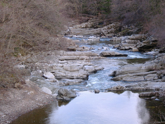
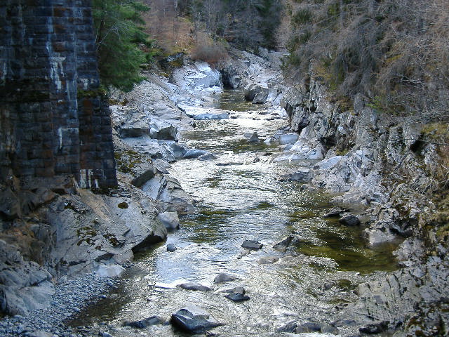
It`s a very scenic gorge, with fascinating rock formations, and from the bridge downwards, the river flows over a series of small rock ledges, followed by three more meaty drops, before it emerges from the gorge and turns back into a flat boulder river. The gorge is only a few hundred metres in length.
Even the bridges are spectacular - with the railway bridge running over the top of the road bridge. This picture is looking up river -
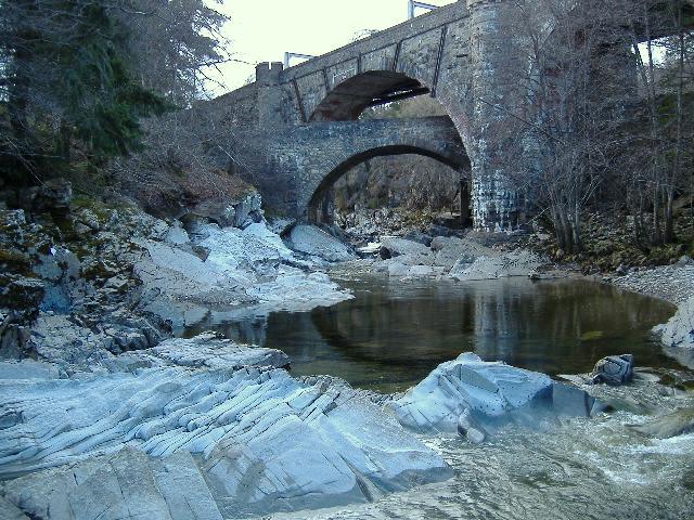
How`s that for a bit of bridge building !
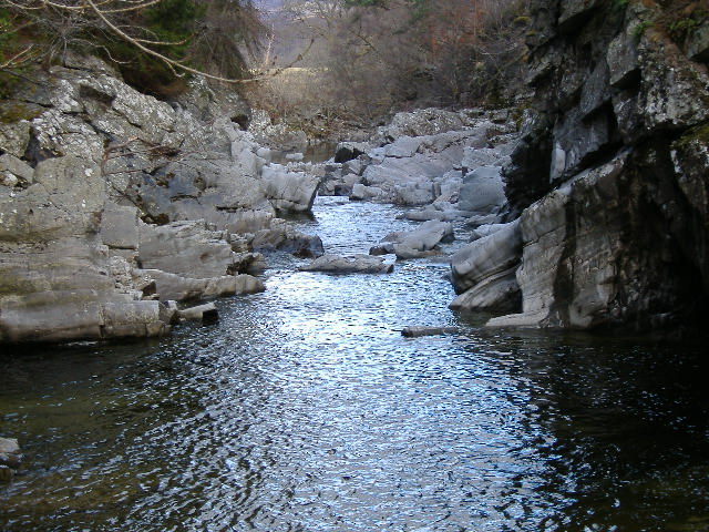
Looking down river from the bridge, it looks like -
The first of the more meaty drops you could probably grade as somewhere between grade 3 and grade 4 - it is a bit messy -
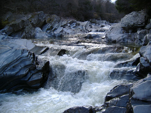
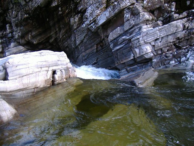
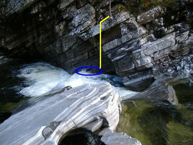
This is quickly followed by a two stage drop which you really can`t assess from high up on the river right bank, what you can see of it looks quite straightforward. Even from further down river, from the river left bank, it looks quite benign, however I didn`t know at the time that you could even get access to the river left bank.
However I am not sure how it should be graded. To an experienced paddler who gets it right, I guess it would be a grade 4. But the consequences of getting it wrong are significant - more on this later.
This is looking down river from beside the grade 4-?, towards the last grade 3 - 4 drop, and the end of the gorge section. Beyond that drop, the river is just a flat stoney river bed.
As I walked down, looking at all the drops, I reckoned it would make an interesting paddle, even though it was very low, so on the way back up, I looked at each drop again, to make sure there was a route down it, and as far as I could see, they all looked okay.
After getting ready, I got on just below the bridge, after a somewhat unpleasant climb down the bank. Some of the small drops were a bit scrapey, the grade 3 - 4 was okay to negotiate down, and the upper sideways ramp down the grade 4-? looked okay .....
Except that I found out the hard way that the water coming down the ramp produced a very fast current right across the intermediate pool above the lower drop, and it drove me at some considerable speed straight into the rock wall on the other side of the river, and I immediately flipped upside down, against the rock face. Not a good place to be - and I ended up out of my boat.
Not wanting to lose any of my gear, I grabbed the back loop of my boat, and also was hanging onto my paddle. Then I got washed down the lower drop - which would have been okay except that my boat was still pinned against the rock face above the lower drop, and it wasn`t going anywhere. I pulled as hard as I could - nothing. So there I was - halfway down the lower drop, hanging from the back loop of my boat with one hand, paddle in the other hand, with my arm getting longer by the second.
Well something had to go, and in a moment of amazing economic decision making, I decided the boat was worth more than the paddle, and so threw the paddle away.
So now I was hanging off the end of my boat with two hands, one hand on the loop, one hand on the tails. But still it wouldn`t budge, and now I had two arms that were getting longer by the second.
Eventually I had to admit defeat, and let go - and because of the current, I shot across the lower pool and under the overhang opposite the drop, and got pinned against the rock under the overhang. After quite a lot of effort, I escaped, swam across the pool and retrieved my paddle which was quietly drifting around waiting for me.
I climbed out onto the rocks river left, and went to have a look at my boat, where it was, and how I could get to it.
In short - I couldn`t. It was pinned against a rock wall - half under water - underneath an overhang - at the bottom of a cliff.
After much pondering, I was becoming resigned to losing my boat, so climbed back down the rocks, grabbed my paddle, and then jumped into the river and swam downstream to where I knew I could get out river right, and would be able to climb up out of the gorge.
As I walked back up the path on top of the cliff river right, I came to where my boat was pinned, and tried to see if I could get down the cliff - eventually I got down to a rocky ledge with a small tree in the middle of it, directly above my boat, and could look down on it, some 3 metres below me.
As I gazed down on it, I realised that the outer end was actually just above the water, and if I could get a rope, I might be able to loop it under the end, pull it up, and maybe dislodge it from where it was pinned. I went back to my van, raked around, and found nothing but two small lengths of chain, some shackles, and two roof rack tie down straps. Well, they would have to do, and took them all back down to the rocky ledge.
Using the chain to weigh down the tie down straps, to form a kind of sling, I tried in vain to get it to lodge under the end of the boat. As soon as I got the chain to swing under the end of the boat, the water flow just pushed it out again. I tried to do it in various different ways, but to no avail. So that was a failure.
Then I used the tree as a belay, and tried to see if I could use the straps as something to hold onto whilst I tried to climb further down, however it quickly became clear that that wasn`t going to work. Another failure.
Whilst I was sitting there thinking about what to do next, my boat suddenly broke free from the rock wall, and headed upstream into the recirculation pool - it circled round, then slammed up against the rock wall again, but this time it was completely under water. If I had not seen it happen, I would not have known it was still there, as it was now completely submerged and invisible - all I could see was the white water of the pressure wave that was holding it in the pin.
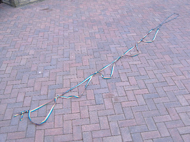
Then I had a brainwave - using figure-of-eight knots, I tied the two straps into an etrier, and used the two bits of chain to make it longer.
Here is the etrier, laid out on some paving. The etrier bit is 3 metres long, and the chain adds another metre.
Using the tree as a belay, I climbed down over the edge and into free space. The etrier was just about long enough to reach the water, but just before getting to the bottom of it, I could swing onto a narrow, sloping ledge, move down this ledge, and then using the etrier as a hand support, was then able to climb down onto a small jutting out bit of rock, level with the surface of the water, right beside my boat.
Here is roughly how it was hanging.
From where I was now standing, I could now crouch down, and reaching down under water, managed to get a hold of the loop at the outer end of the boat, and much to my surprise, I pulled it up quite easily.
Success ! I had my boat - except what could I do with it - so eventually I pushed it over the lower drop, and it followed exactly the same route that I had done earlier - and it ended up pinned against the rock wall on the other side of the pool underneath the overhang. And there is stayed.
There was only one way I was going to get it out, so I jumped out over the stopper into the pool, and followed exactly the same route to the rock wall opposite. After a lot more effort, I managed to extract the boat, and swam with it to some rocks that were just level with the surface of the water, and emptied it out. I climbed in, and hand paddled round to where I could get it out and up the side of the gorge.
Happiness is getting your boat back !
The epilogue
I was back up in the same area the following day, and that was when I took all the photographs. I also discovered that there is also a path river left above the gorge, running through the trees. You need to go through a small archway underneath the railway line to get to it.
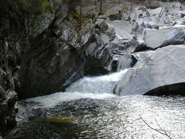
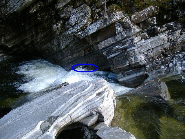
Here is what the grade 4 looks like, looking down from the river left path - you get a much better view of what this rapid is about from this side, you just don`t see it properly from the river right path.
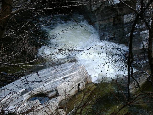
From this photograph, it looks as if there is quite an easy line down the first ramp, then turning and dropping over the second drop. However I think there are several particular danger points with it -
- the speed of the fast current down the ramp catches you out if you are not prepared for it - it isn`t a drop, it is a ramp which leads straight onto the rock face, and will pin a boat
- the intermediate pool at the bottom of the ramp has quite a significant recirculation - I think this may get worse as the river level rises, as the ramp right across the open side of the pool means that the water level at the open side of the pool is higher than the water level at the back of the pool, so making an exit from the pool more difficult. The hydrodynamics of the pool are I think quite complex. At low levels, some of the water coming down the ramp will peel off to the left. Some of it will hit the rock face and form a pressure wave, and some of it will peel off to the right and form the recirculation current in the horizontal plane - the water that is circulating will eventually exit out of the pool by sliding underneath the water coming down the ramp, a bit like a spiral staircase. As the river level rises, water starts flowing down into the pool from above, at the back wall of the pool. This water will form a stopper, and like all stoppers, will recirculate in a vertical plane. This will further accentuate the fact that the water at the front of the pool is higher than the water at the back, against the back wall
- the lower drop isn`t a clean drop, it has a bit of a ramp, so as the river level rises, the stopper at the bottom of the lower drop is going to get increasingly sticky
- the current across the large bottom pool below the lower drop drives swimmers and errant boats straight into a rock face underneath a significant overhang - the exit from this pool is quite narrow, and is choked with boulders, so the level in the pool will rise quite quickly, and the level will not have to rise much before there is no air space under the overhang
- if the river rises significantly, water will start to flow over the long sloping slabs of rock river left of the drop - and the long slope will produce a very sticky stopper at the bottom of it. In addition, as can be seen in one of the photographs above, the sloping rock has a considerable undercut, so there is a strong possibility of a backward recirculation as well as the more normal recirculation downstream of the rock - and a backward recirculation is impossible to escape from
When I ran the river, it was a bit lower than the level shown in all these photographs.
If you are going up to have a look at this bit of the Garry, be aware that there is only limited parking - maybe 2 or 3 cars on one side of the bridge, and 2 on the other side.
Be sure to scout the river first from the river right bank, which will show you most of the rapids. Then also scout from the river left bank, to see the grade 4-? properly. It is possible to climb down from the river left bank onto the rocks beside the grade 4-?, and from there you can get a proper look at both the grade 4-?, and the grade 3-4 just above it.
It may be possible to access the Garry further upstream, and come down more rock shelves. Here is what it looks like, looking upstream from the bridge.
Be-aware, there is a sign at the entrance to the river right path warning that the flow of water in this section of the Garry is controlled by dams, so there is a considerable risk of rapid changes in river level.
Finally, it never ceases to amaze me that a river that is so low that you are scraping down small drops, can produce such power on a larger drop - I have seen it before, and I will probably see it again. More diligent scouting is called for, especially on unknown rivers.
PS - an update
Some time after I had failed in my attempt to do this section of the Garry, somebody told me that this grade 4? waterfall is usually rated at grade 5 or 6.
I don`t think I would argue with that !
website design by ron-t
website hosting by netnerd.com
© 2025 Ron Turner
![]()
![]()