ron-t kayaking blog
30 September 2012 .............. Dorus Mor
The Dorus Mor is either a famous or an infamous feature of the Argyll area, depending on your point of view. It lies just to the south of the Craignish peninsula, between Craignish Point and the island of Garbh Reisa. It is part of the connection of Loch Craignish to the Sound of Jura.
The Dorus Mor is subject to some very strong and very confused tide races - during Springs the water speed can reach 8 knots.
According to my pilot, during Springs the westerly flowing flood tide through the Dorus Mor starts at 04:30 after Oban high water, and the easterly flowing ebb tide starts 01:45 before Oban high water. During Neaps, they start some 45 minutes later.
I have been there twice now in the last few days. For my first trip, on Thursday last, I did what was very much a rather short and cautious trip, timed to coincide with slack water before the start of the ebb tide. I probably spent as much time standing or walking about on the land down at Craignish Point as I did paddling.
It was a few days before Springs, so things were not as hairy as they would be during Springs.
I launched from a handy wee beach just up the road from the car park at the end of the public road, and it was quite a straightforward paddle down towards Craignish Point. However it did get quite rough as I approached the westerly point, Rubha na Traighe, but I could see that just round from the point it was quite calm, so I just kept going through it.
Once round the corner it was calmer.
There was quite a strong wind coming up from roughly the south west, so I couldn`t really decide whether the roughness was caused by the wind or the tidal flow - maybe it was the combination of the two.
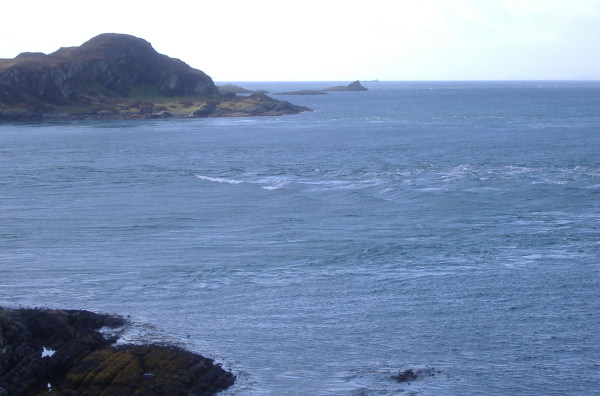
I headed along the shore past the other headland Rubh an Lionaidh so I was looking up Loch Craignish, and landed there. Just to prove I was there, here is the view looking across the Dorus Mor to Garbh Reisa.
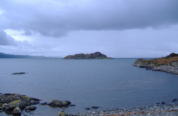
It looks very calm in that photo, it wasn`t really that calm, and it was quite windy as well.
I didn`t want to hang about as I had to go back round Rubha na Traighe, so it was back into the boat and I headed off.
Immediately beyond Rubha na Traighe there was now a lot of white water, it didn`t look very welcoming, so I came back a bit, landed again, and climbed/walked right out to the point.
From up on the rocks above the point, I could see there was a less confused channel quite close to the rocks to the side of the point, with just about 20 metres of confused water to paddle through, so it wasn`t going to be too bad. Even if it hadn`t been there it would not have mattered, because I could have paddled back up Loch Craignish instead, then walked back down the road to pick up my van. So I had an escape route.
From up on the rocks, you get a better view looking south, because you can see down the island chain to the south of Garbh Reisa -
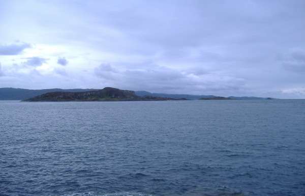
Looking across to the west and south west Jura dominates the outlook, and you can just see the Paps of Jura showing through the rather grey weather. You also get an impression of the tidal current in the Sound of Jura.
Back in my boat, I followed best practice in white water paddling - look at and concentrate on where you want be, and go for it. Don`t look at the very unwelcoming bit just a few metres to the left and I was soon through it and into the calmer water.
Beyond this bit of calmer water there were some quite big waves over the next couple of 100 metres or so, but it gradually got less, and it wasn`t long before I was back at the beach, so I went for a paddle further up the side of the Craignish peninsula for a while.
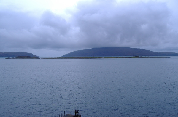
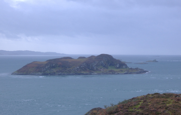
Back at the car park, you get a good view across the top of Reisa Mhic Phaidean and Coiresa out to the Corryvreckan and Scarba with the hat on.
Many years ago I went across to Jura for a couple of days - on the first day I climbed the Paps of Jura - a very long walk across miles of bog, then up the first Pap, back down to the bog, up the next Pap, back down the the bog, then up the third Pap, back down and a long walk back out across the bog.
On the second day I cycled right up to the top end of Jura, walked the last bit and stood and looked at the Gulf of Corryvreckan - I think it was completely flat and not very interesting. More interesting were the wild goats that live in the caves there.
As I said, it was a short trip, the main purpose was to have a first look at the Dorus Mor. It was a pity about the wind, because that was causing waves that were hiding the tidal flows, I would rather have seen them than the waves.
Today I did the second trip to the Dorus Mor, this time I deliberately chose the full Springs, and I timed my visit to get there during slack water before the flood tide.
I didn`t want to tangle with Rubha na Traighe during the Springs and in a strong wind, so this time I launched into Loch Craignish, and paddled down towards the point Rubh an Lionaidh.
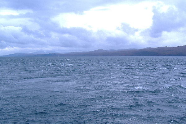
Most of the way down the loch it was fairly calm and it was a pleasant easy going paddle. But over the last 300 metres or so it got progressively rougher.
Going round Rubh an Lionaidh was okay, and paddling across towards the other point Rubha na Traighewas okay, but approaching the point before Rubha na Traighe, I began to get a bit concerned about the water flow around that point, so turned back, and went back towards Rubh an Lionaidh. As I approached the point, I could see a distinct shear line in the water just at the point, and as I crossed it the bow was pushed quite hard round to the right - it was quite hard to get it back round again so I could go past and round the point. So in just the time it took me to paddle across the bay and back, something was developing at Rubh an Lionaidh.
I headed back into Loch Craignish for a couple of 100 metres or so, until I came to a place I could get out. I pulled the boat high up onto the grass well beyond the seaweed line, and walked back towards the point.
I spent the next half hour or so sitting on top of a small hill overlooking Rubh an Lionaidh getting blasted by the wind, and watched the flood tide develop.
It was very clear that there was a lot of water coming up between Garbh Reisa and the mainland - some of it was flowing into Loch Craignish, and some of it was curving round and flowing through the Dorus Mor between Garbh Reisa and the Craignish peninsula.
I was really quite surprised by the amount of water flowing into Loch Craignish - it was a very strong current, and the whole mouth of Loch Craignish was very rough. This continued all the time I was down at the bottom of the peninsula. Loch Craignish is quite a short loch, so I don`t know where all this water goes.
The water flow through the Dorus Mor was fairly even across the width of the Dorus Mor, except that about a third of the way across there was a section where there was a distinct tide race, with quite big waves. The waves were continually changing shape, they weren`t static waves by any means. You can see them here.
I am not sure if you could regard them as possible playwaves, although they almost are - I don`t think they really develop enough, and there is no adjacent eddy, so to get to them would mean a straight fight against the main current. As that could be running at up to eight knots I don`t think you would succeed.
The other thing that was noticeable was that there were three distinct shear lines. The first one is the one I already met, just off Rubh an Lionaidh. The second one is off the north end of Garbh Reisa, where Garbh Reisa is stopping the tidal flow. The third one is off Eilean na h-Eairne, which is at the southern end of the line of islands south from the Dorus Mor. These shear lines can be friend or foe, as they mark the end/start of tidal flow. It was quite clear that the islands provide a dam across the tidal flow, with calmer water in their shadow.
After half an hour or so, I headed off to the other point. The bottom end of the Craignish peninsula is characterised by two ridges, one either side, with a lower very boggy bit in between. The two ridges end in the two points Rubh na Traighe and Rubh an Lionaidh.
Beside Rubh na Traighe there is another un-named point, and I went there first. There I discovered just what had caused me to turn back earlier.
There is a massive eddy which forms at the west end of the Dorus Mor. The westerly going water flows almost through the Dorus Mor, then the landward side of the stream turns and heads straight for this un-named point, then turns again and heads east into the bay. It is going at one heck of a speed - probably as fast as the west going current, so could be eight knots. It certainly looks fast standing beside it.
There is no way you could paddle west against it. If you were coming east round Craignish Point, you would have an exciting ride. I tried to photograph it but it doesn`t really show in still pictures.
Close to Rubh na Traighe itself there didn`t seem to be too much current, the main flow was a bit further out.
After visiting the two westerly points, I headed up the westerly ridge - it provided a rather nice bit of scrambling up the rocky end of the ridge. From the top of the ridge I could see quite clear shear lines just at the south end of both Reisa an t-Sruith and Reisa Mhic Phaidean/Coiresa - they were a bit too far away to show in photos.
I could also see the white tops in the Corryvreckan, so something big was happening out there.
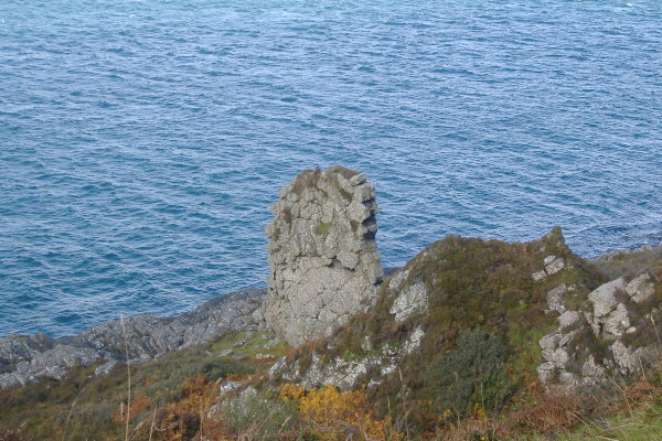
When I was coming down the west side of the Craignish peninsula on my previous trip I saw a large fin of rock sticking up out of the side of the hill. It is an impressive sight, but I couldn`t photograph it from the boat. So here it is from higher up. A wild guess would say it is about 2 metres wide and about 15 metres high. It is certainly quite a feature.
After crossing back over the peninsula and onto the east ridge, I noticed that despite its rocky appearance from sea level, Garbh Reisa has quite a flat top. A bit curious. It was also very noticeable that there was no sign of the tide race in the Dorus Mor, it was now a smooth tidal flow.
Back at my boat, it was time for lunch, and then I headed back up the loch. Surprisingly, it certainly wasn`t an easy paddle back up the loch - there was a strong tidal current, and a strong wind on my back, so there were some quite big waves which just took over control of the boat, and they decided which way I was going to go. This continued all the way up the loch until I got into the shelter of the bay into which I launched. It was hard work and somewhat scary, but I didn`t half shift up the loch !
I still don`t know where all the water flowing into Loch Craignish goes, but it was a great day out.
website design by ron-t
website hosting by freevirtualservers.com
© 2024 Ron Turner
![]()
![]()