Munros + Corbetts - 2009
26 June 2009 ........ Bruach na Frithe, Bhasteir Tooth, Am Basteir, Sgurr nan Gillean
Another high over the North Sea, an east wind forcast for the next several days - time to go west again - this time to Skye.
I had a particular target - something I have wanted to do for a few years now - climb the Bhasteir Tooth. I also needed to climb Bruach na Frithe, Am Basteir, and Sgurr nan Gillean for the second time - for my munro bagging round 2.
Another thing I wanted to do was to climb Bruach na Frithe from the Glen Brittle side - I did them from Sligachan the previous times.
I started from the car park at NG 423 258, and headed up the track towards Sligachan, after a couple of km`s, I turned southeast, and headed up the ridge. It is an easy enough walk - I must confess, I followed the path all the way to the summit, rather than cut off to the left and scramble up the crest of the ridge - I was trying to save time !
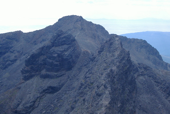
As you get higher up the ridge, you begin to get some good views of the section of the Cuillin ridge to the south of Bruach na Frithe down to Sgurr a Mhadaidh, which is a bit of the Cuillin ridge I have never done. I believe it has some fairly tricky bits. Here is a view looking along the flank of Bruach na Frithe, with the peaks of An Casteil on the left, then the three peaks of Bidein Druim nan Ramh in the centre, and then Sgurr a Mhadaidh on the right.
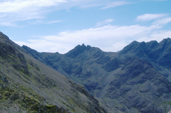
There is one peak that this photograph doesn`t show, as it is hiding round behind the flank of Bruach na Frithe - it`s Sgurr na Bhairnich.
A bit more to the right, and you get a very good view across to Sgurr a Mhadaidh and Sgurr Thuilm.
I spent a lot of time trying to work out which summit is which - the thing that was confusing me was the jumble of peaks to the left ( ie - north east ) of Sgurr a Mhadaidh. These peaks are not shown on the OS 1:50,000 map sheet 32, and they are not shown in either of the diagrams in the two SMC books I have got, that cover the Cuillins. Eventually I found that they are shown on the OS 1:25,000 Explorer map, sheet 411 - though you do need a magnifying glass to see them. Once I had found that, the other summits fell into place.
After doing all this head scratching over Sgurr a Mhadaidh and its jumble of peaks, I went out and got the Harvey`s map of the Cuillin ridge. This does show the various tops, and even gives them names - First Top, Second Top, and Third Top. I don`t know if these are official names, or Harveys invention, but at least it enumerates them.
The Harvey`s map also names the three tops of Bidean Druim nan Ramh - the centre one is Bidean Druim nan Ramh, the other two are North Top and West Top. So it looks as if the Harvey`s map is a good investment.
I find it odd that none of the maps I have show the path up the NE ridge of Bruach na Frithe from the cairn at the top of Bealach a Mhaim - it is a well defined path, and from my limited knowledge of the Cuillins, I reckon it is the easiest way up Bruach na Frithe, both from Glen Brittle, and from Sligachan. It is certainly easier than the scramble up from Coire a Bhasteir, round and up past the base of Am Basteir, and up the east ridge of Bruach na Frithe. It is also a lot more pleasant, as you are out on a ridge with a view and some air, instead of being enclosed by Sgurr a Bhasteir and Am Basteir.
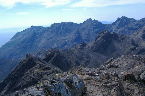
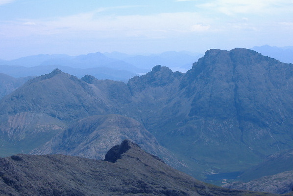
The summit of Bruach na Frithe provides the most amazing view in every direction - last time I was up there the visibility was incredible, and I could see the whole of the Western Isles, from the Butt of Lewis right down to Berneray. On this occasion it was more hazy, so visibility wasn`t so good. However local views were still good in every direction. Looking southwards, here`s two parts of the Cuillin ridge, in the middle distance, we are looking across or along Sgurr na Bhairnich, then An Casteil, then Bidean Druim nan Ramh.
In the background we can see part of the bottom end of the Cuillin ridge - I think we are seeing, from the left - Sgurr Dubh Beag, then Sgurr Dubh Mhor, then a block of Sgurr Alasdair, Sgurr Thearlaich, and Sgurr Mhic Choinnich, and finally Sgurr Dearg, An Stac, and the Inaccessible Pinacle. The very bottom part of the Cuillin Ridge is hidden behind Sgurr Dubh Beag and Sgurr Dubh Mhor - you can just see it peeking through a gap.
Further round to the right, we are now looking down on Sgurr an Fheadain, and the ridge that runs eastwards from there up to Bidein Druim nan Ramh. Behind that, we`ve got another view of Sgurr Thuilm and the jumble of peaks round Sgurr Mhadaidh, and then in the background, it could be Sgurr a Ghreadaidh and/or Sgurr na Banachdich.
Looking east south east, we get a good view of the corbett Garbh bheinn on the left, then Sgurr nan Each, down to Arch Gully, up to Clach Glas, and finally Bla Bheinn on the right. It is an impressive looking ridge, and I believe it is quite a hard route - both Clach Glas and the north/east side of Bla Bheinn are quite challenging.
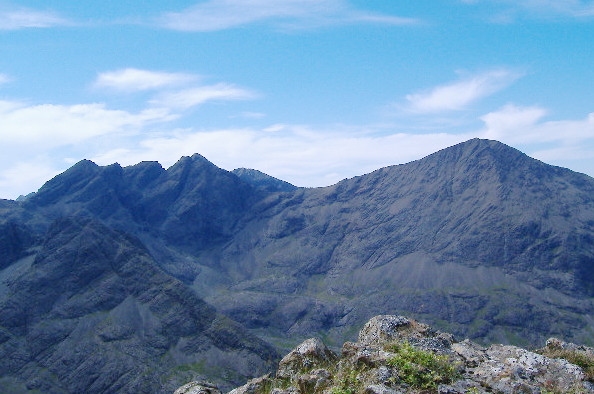
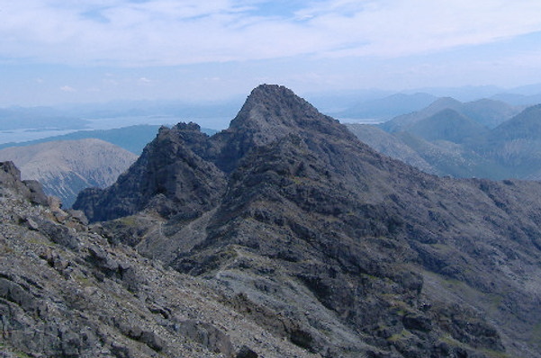
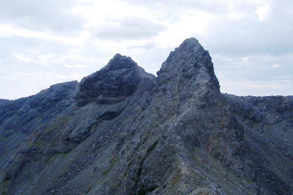
Looking eastwards from Bruach na Frithe, we get the view of what is to come - Sgurr a Fionn Choire at the front, Am Basteir to the left, and Sgurr nan Gillean at the back.
The west ridge of Sgurr a Fionn Choire is a scramble, but it starts with quite a difficult move, so I veered round to the left, and climbed up the north side, which is a straightforward scramble. The strongest reason for climbing Sgurr a Fionn Choire is the view you get of Am Basteir and of the Bhasteir Tooth.
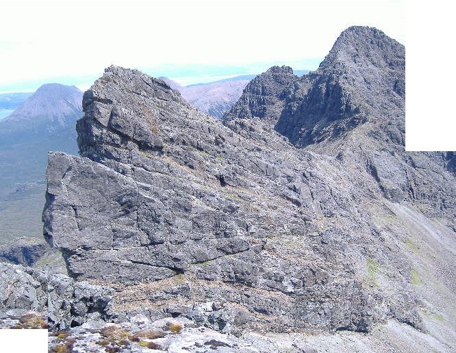
I am sorry about the missing corners - I was too close to the Bhasteir Tooth and Am Basteir, so couldn`t get it all into one photograph. This picture is actually two photographs stuck together.
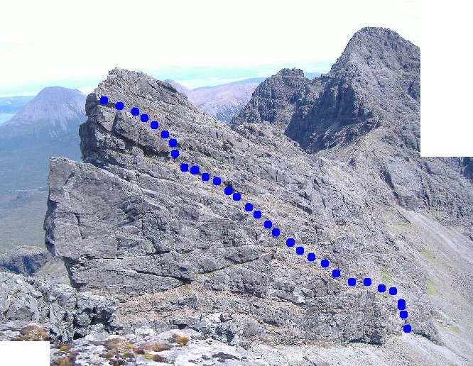
There are, I think, six acknowledged routes up the Bhasteir Tooth - two of them involve rock climbing up the face that we are looking at. A third one, the easiest, is known as the "Lota Corrie Route", and is, I think, shown here.
My navigation skills weren`t just as good as they should have been - for a start, I don`t think I went far enough down into Lota Corrie, and ended up climbing a wall of rock about 3-4 metres high by a rather zig-zag route. Then at the top, I climbed too high, and ended up just below the summit of Am Basteir on a big sloping slab of rock, looking down on the Bhasteir Tooth.
So I had to come away down again to get to the Bhasteir Tooth.
When I was on Sgurr a Fionn Choire, one of the things I had looked at was the possibility of climbing from the Bhasteir Tooth up to the summit of Am Basteir, without dropping all the way back down to the Lota Corrie, and I reckoned it might be possible. So once I was on the Bhasteir Tooth, I came back down to the Nick, then climbed back up again to where I had been before. There was no possibility of me climbing up from the sloping slab of rock below the summit of Am Basteir - it was an overhang. So from a bit lower down I climbed up from ledge to ledge, but eventually got stuck. There was a 2 metre high wall of rock right along the side of the ledge, and I could not get up it. I was a bit wary about trying too hard, as if I had fallen backwards, the ledge would not have contained me, and I would have had a big drop.
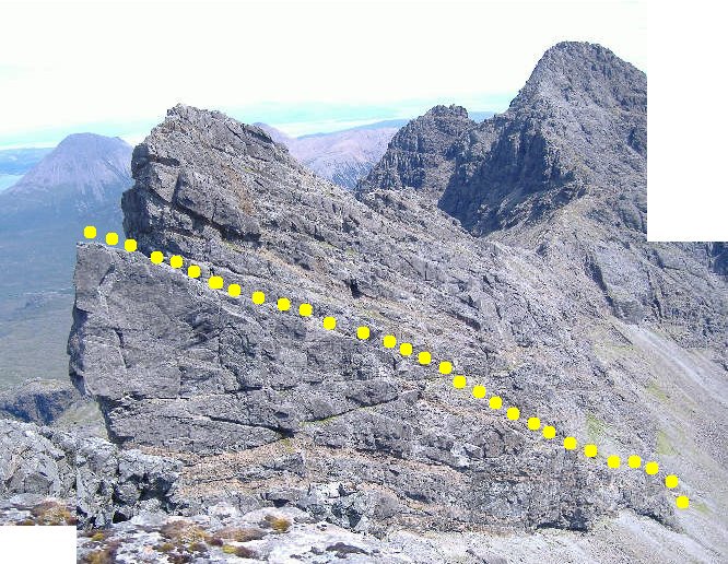
I traversed down this ledge quite a long way, all the time with this wall I couldn`t get up. Eventually I found a break in the wall, and was able to scramble up away from the ledge, and after a bit more scrambling, ended up on top of the east ridge of Am Basteir, just at the bottom of the 3m wall which breaks the ridge. My route was roughly -
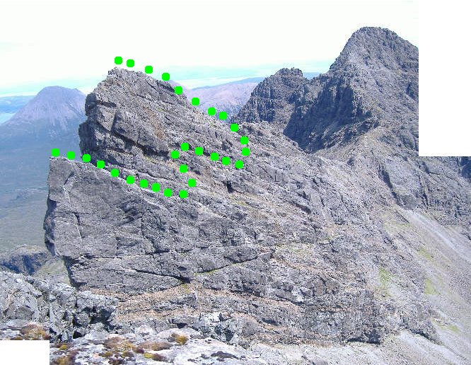
I don`t guarantee the accuracy of this - I am not sure which of the various ledges you can see in the picture was the one I traversed down. But it is approximately right.
The ledge not only sloped down in front of me, it also sloped down sideways as well, and there was an overhang above the ledge at one point to negotiate as well, so it wasn`t the easiest of routes. Adding to that, the ledge is quite open and exposed, above quite a big drop, so I`m not recommending it as a way up Am Basteir.
The route back down the east ridge of Am Basteir is straightforward, apart from the 3m wall which blocks your way. It took me quite a long time to get up it - I knew I had to get my right foot onto that nice foothold 1m up, on the right hand corner - but I could not work out how to get it there. I always ended up with my left foot on it. You have to climb the bottom bit the wrong way, to get your right foot on it. However eventually I got there.
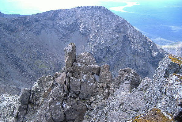
The west ridge of Sgurr nan Gillean is not difficult, apart from the bit at the bottom. I am still not sure how I did it - I didn`t go up either chimney, which are the normal routes. I went up the edge of the ridge - which has got some rather scary bits, where you have to work your way across some gaps, with nothing on either side. So it is a bit like climbing on air. But once you`re above the second chimney, the ridge broadens out, and it is a straightforward scramble to the summit. And of course you have to go through the hole just below the summit -
As an aside, the easiest way up Sgurr nan Gillean is by the south east ridge - here is what it looks like from Sgurr a Fionn Choire. There is still a fair bit of scrambling to do, but it easier than the west ridge. However it is a long trek from Sligachan.
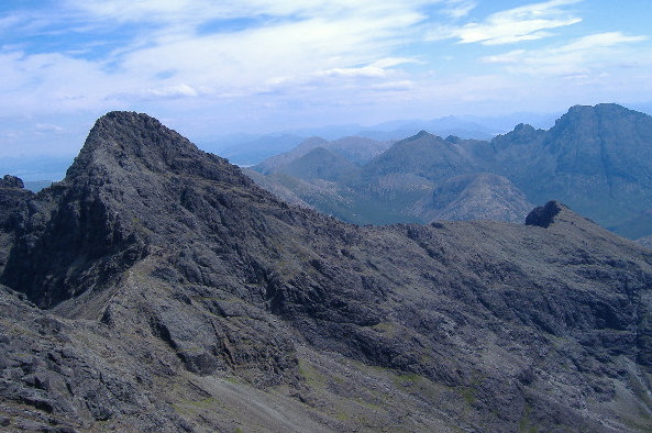
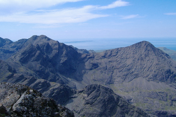
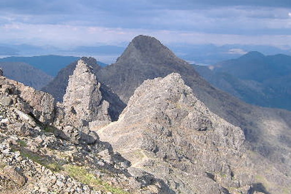
From the summit of Sgurr nan Gillean, the view looking west is quite impressive - you are looking across to Am Basteir, Sgurr a Fionn Choire, and Bruach na Frithe.
From further down, Am Basteir looks even more scary - I have no recollection of where or when I took this photograph.
I think it was possibly taken from around the coll - Bealach a Bhasteir, when I was about to head up Sgurr nan Gillean.
On the way down, I didn`t dare try to free climb back down the bottom end of the west ridge of Sgurr nan Gillean, as I was getting quite weary, so I rigged my ropes and partly abseiled and partly climbed down Tooth Chimney.
It was then a long trek down and round the base of Am Basteir, and back up to the summit of Bruach na Frithe. Just as I was leaving there, a shaft of sunlight lit up some of the peaks, but not others, so it made an interesting picture looking east again, and shows off Sgurr a Fionn Choire and Am Basteir rather nicely.
It was then back down the path down the north east ridge of Bruach na Frithe, and back to the car park. I got back about 21.00 hrs, so it was quite a long day. But my mission was accomplished.
Finally - there seems to be some variation in the spelling of Bhasteir or Basteir, depending on which map or book you are looking at :-
- if they show them at all, they all refer to Coire a Bhasteir, Loch a Bhasteir, Sgurr a Bhasteir, and Bealach a Bhasteir
- they all refer to Am Basteir
- one of my SMC books refers to Basteir Tooth, the other SMC book refers to Bhasteir Tooth
- the Harvey map refers to Bhasteir Tooth
So I have no idea which is correct.
website design by ron-t
website hosting by netnerd.com
© 2025 Ron Turner
![]()
![]()